The Boogie Woogie Heritage Driving Tour
By John Tennison, MD Copyright November 21, 2012
"I searched around many towns for the birthplace of Boogie Woogie. In the end, one thing I found: I'm partial to Marshall." -- from the song “Bring the Boogie Woogie Home” by John Tennison, MD
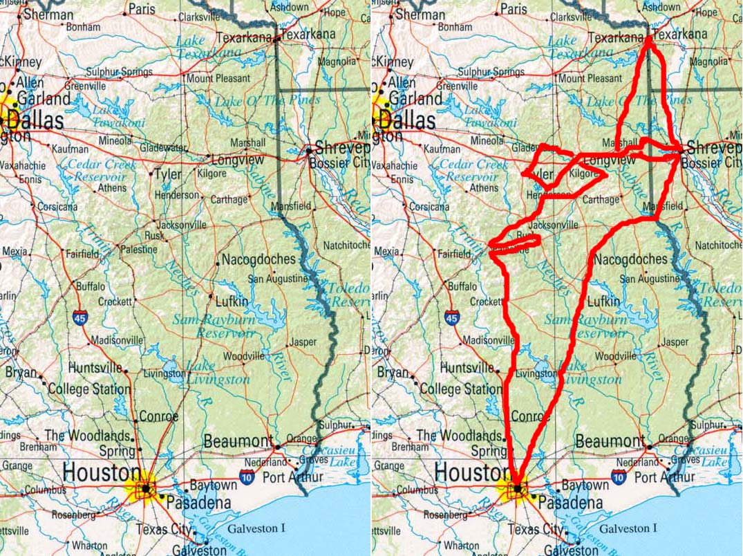
The map to the left above is duplicated in the map to the right above, with the addition of the red line, which shows the route of the Boogie Woogie Heritage Driving Tour.
Introduction
My Boogie Woogie research and performances have resulted in my having driven and flown many thousands of miles. Given this background, I am sometimes asked to make recommendations of locations of historical significance to Boogie Woogie to which a tourist or Boogie Woogie Pilgrim could travel by car. As a result I have decided to describe a driving tour that will incorporate what I consider to be important areas and municipalities in the history of Boogie Woogie. This tour will include some of the areas which were especially important in the 1870s. Large portions of this tour will run parallel to historic railroad tracks that were used extensively by itinerant Boogie Woogie musicians. I have not included every possible destination which would be meaningful to a Pilgrim of Boogie Woogie.
Because this first Boogie Woogie Driving Tour is intended to emphasize the earliest areas that were important from the early 1870s through the early 1880s, I did not include the portion of U. S. Highway 59 (The Boogie Woogie Highway) between Marshall and Tenaha. However, once the railroad reached Carthage in the late 1880s, itinerant Boogie Woogie musicians could easily travel to the Carthage area, and thus, the portion of Highway 59 between Marshall became more important. Moreover, I have not included the portion of U. S. Highway 59 between between Houston and El Campo, the birthplace of Little Willie Littlefield. This is because, in the first decade following the creation of Boogie Woogie, El Campo was not yet as likely to be a destination as compared to the areas on the red-lined route of the Boogie Woogie Heritage Driving Tour.
From the late 1880s onward, many other areas of Texas and Louisiana could rightfully be included in a Boogie Woogie Driving Tour. At some point in the future I will delineate additional driving tours that reflect areas relevant to the history of Boogie Woogie from the late 1880s onward.
This article will be updated over time to become more comprehensive, but for now, this article can serve as a rough guide to some important destinations. I have included more detail for Arklatex destinations, but in time, I will add more details to the descriptions of destinations outside of the Arklatex.
I will describe the specific roads to take and provide brief annotations as to why a destination is important or what extant sites of interest are at a particular destination. Destinations on the Boogie Woogie Heritage Diving Tour have been arranged in an order that is geographically convenient, but not necessarily correlated to the chronology of the historical developments of Boogie Woogie.
The Boogie Woogie Heritage Driving Tour is not necessarily intended to take travelers in proximity of modern-day venues where Boogie Woogie is performed, but rather, the purpose of the tour is to bring travelers in proximity to locations where Boogie Woogie was created and/or underwent its earliest developments.
This driving-tour article assumes that readers are already familiar with my other writings on Boogie Woogie. To the extent that drivers of this tour route are not already familiar with my other writings on Boogie Woogie, the magnitude of significance of the various destinations might not be as apparent.
The driving tour starts and ends in Marshall, Texas, the Birthplace of Boogie Woogie. However, for many people, especially those who are not already near Marshall, it might make more sense to start the tour at points near a major airport, such as the Bush Intercontinental Airport in Houston, Texas or the Shreveport Regional Airport in Shreveport, Louisiana.
For those who would like a shorter tour, I would suggest limiting yourself to Destinations 1 through 20. In doing so, you will drive a loop in the Arklatex that starts in Marshall, goes to Texarkana, then to Shreveport, and then ends up back in Marshall. If you prefer a slightly longer tour, you could limit yourself to Destinations 1 through 27, and then head back to Marshall from Tatum on Texas 43.
Even if you didn’t care about Boogie Woogie, the Boogie Woogie Heritage Driving Tour route (Destinations 1 through 41) will take you through some beautiful areas, including a lot of East Texas, some of Louisiana, and a little bit of Arkansas.
1. Marshall, Texas - The Birthplace of Boogie Woogie (Harrison County)
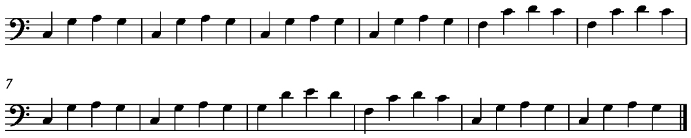
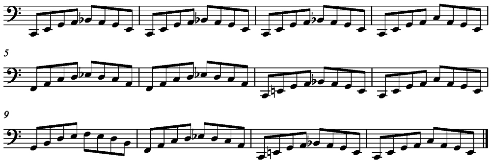
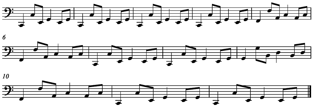
Marshall, Texas is the Birthplace of Boogie Woogie, i.e. the most probable municipality to contain or be nearest to the geographic center of gravity of the earliest performances of Boogie Woogie in the early 1870s. What is likely to have been the earliest Boogie Woogie bass figure was called “The Marshall” and was named after the town of Marshall.
The "Marshall" Bass Figure

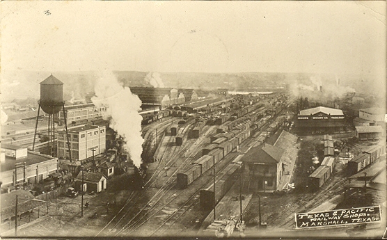
While in Marshall, visit the historic Texas and Pacific Depot and Museum at the northern terminus of North Washington Street. While in the museum, be sure and see the beautiful enlarged panoramic photos of the Texas & Pacific Railroad Shops from the early 20th Century. Visit the historic Texas & Pacific steam locomotive on display at the Depot. Visit the location of the boyhood home of Floyd Dixon at 1203 Evans Street. (FYI: the return route to Marshall on the Boogie Woogie Heritage Driving Tour will take you by the gravesite of Omar Sharriff at the Algoma Cemetery on Victory Drive. See Destination #20.)
The pianist known as "Roadmaster" (whom Floyd Dixon said was the best pianist he had ever heard, even when considering Art Tatum) performed in the Marshall area.
Very important developments in Boogie Woogie bass figures occurred along Texas & Pacific Railroad corridor between Marshall and Texarkana. Highway 59 runs roughly parallel to this railroad corridor. Thus, from Marshall, travel northward on Highway 59 (The Boogie Woogie Highway) to the intersection of Texas 49 (AKA Broadway Street) at Jefferson, Texas. Turn right (eastward) on Broadway Street and continue to the the intersection of Broadway and St. John's Street.
2. Jefferson, Texas (Marion County)
Jefferson is the first destination you will reach as you travel northward from Marshall to Texarkana. There is a Boogie Woogie bass figure named “The Jefferson,” which is said to have developed in the Jefferson area and might have been influenced by bass figures used in music that had come by way of steamboats to Jefferson from New Orleans.
The "Jefferson" Bass Figure
While in Jefferson, visit Jay Gould’s railroad car. Visit the Texas & Pacific model train display. Visit the areas to which steamboats used to travel and dock.
From Jefferson, continue traveling northward on Saint John Street (AKA Texas 49). When you reach the intersection of Texas 49 and Texas 248, turn left and go over the Texas & Pacific tracks. Continue northward on Texas 248 towards Bivins. Texas 248 will run roughly parallel to the Texas and Pacific tracks as you travel northward towards Bivins. When you reach Texas 125 turn right (eastward) and then immediately turn northward again, which is the continuation of Texas 248 towards Bivins. Stop in Bivins at the intersection of Texas 248 and Texas 43.
3. Bivins (AKA Hoxie's Station) (Cass County)
Based on examination of railroad maps of Cass County from the late 19th century, it appears that the modern-day community of Bivins is located where Hoxie's Station was originally located (at a distinct westward-bowing curve in the Texas & Pacific tracks). Based on examination of these same 19th-century Cass County maps, it appears that Hoxie was first re-named "Wayne." The community of Wayne then later assumed the Bivins name. Based on the late 19th century railroad maps, the original Bivins location appears to be north of modern-day Bivins, but south of what had been the Galloway stop.
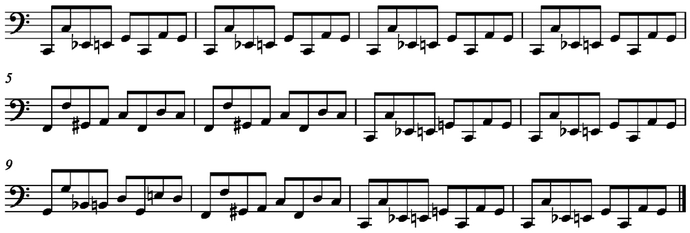
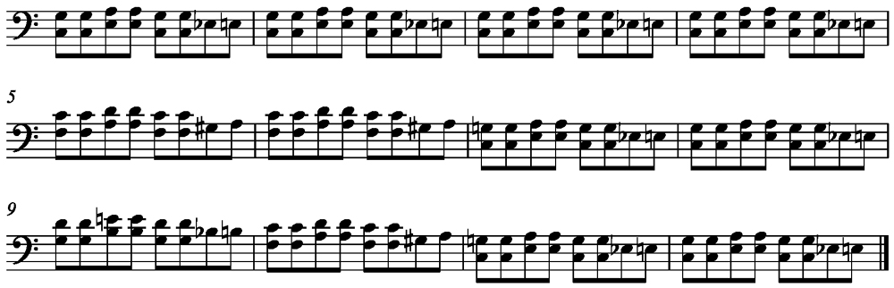
Hoxie's Station developed in the early 1870s when the Texas & Pacific Railroad was being constructed through Cass County. A well-known Boogie Woogie bass figure, the "Hoxie," is said to have been developed at the community of Hoxie during the construction of the Texas & Pacific railroad tracks in 1873. “The Hoxie” is a variant of “The Marshall” bass figure. Moreover, “The Hoxie” is a precursor of the “Texas and Pacific” bass figure (AKA “the Cows”), which is the most influential and famous Boogie Woogie bass figure of all time.
The "Hoxie" Bass Figure
T-Bone Walker's mother, Moviela Walker (on page 9 of Stormy Monday, the biography of T-Bone Walker by Helen Oakley Dance), mentions her father, Edward Jamison (T-Bone's maternal grandfather), having worked at various logging camps run by the Grogan Brothers, one of which is described as being "Biven," which was almost certainly the community currently known as "Bivins." Another logging camp mentioned by Moviela Walker was located at Kildare, which is just south of Bivins in Cass County on the T&P mainline.
Just west of here (by way of Texas 1841) is Linden. Linden is the county seat of Cass County. T-Bone Walker was born in Linden in 1910. Linden is also a location mentioned by Moviela Walker when recalling locations of the logging camps where her father had worked.
It is plausible that T-Bone Walker might have been exposed to Boogie Woogie in Cass County prior to moving to Dallas. However, the following quotation is attributed to T-Bone Walker (page 52, in the book, "Honkers and Shouters" by Arnold Shaw):
"The first time I ever heard a boogie-woogie piano was the first time I went to church. That was the Holy Ghost Church in Dallas. That boogie woogie was a kind of blues."
This quotation of T-Bone Walker does not rule out the possibility that T-Bone heard Boogie Woogie on an instrument other than piano, such as guitar, prior to hearing Boogie Woogie played on piano at the Holy Ghost Church.
Census data from 1870 indicate that, when he was 2 years old, Scott Joplin was living in Cass County not far from Linden. This evidence suggests that Scott Joplin might have been born in Cass County.
The Texas and Pacific Railroad did not build through Linden. However, after construction of the T & P corridor between Marshall and Texarkana by 1873, two railroads were later built from this T & P corridor to Linden.
1. The Kildare and Linden Railroad completed 13.30 miles of track from Kildare (on the T & P corridor in Cass County) to Linden by 1889. This track was abandoned in 1901.
2. The Jefferson and Northwestern Railroad completed its railroad from Jefferson (on the T & P corridor in Marion County) to Linden (a total of 19.80 miles) by 1933, but then abandoned this track in 1942.
In modern times, Linden has come to be known as "Music City Texas." Linden is the site of the annual T-Bone Walker Blues Festival, which has featured artists who play Boogie Woogie. Linden is also the birthplace of modern-day musician and Eagles founder, Don Henley.
From Bivins, travel northward on Texas 43 towards Atlanta, Texas. Texas 43 will become Louise Street in Atlanta. When you reach the intersection of Louise Street and Main Street (AKA Texas 249) turn right (eastward) and travel 2 blocks (over the railroad tracks) to the intersection of East Street and Main Street.
4. Atlanta, Texas (Cass County)
Visit the old Texas & Pacific depot on the northwest corner of the intersection of Main and East Streets in Atlanta.
From the intersection of Main and East Streets in Atlanta, do a U-turn and go back westward 2 blocks to Louise Street. Turn right (northward) on Louise Street (AKA Texas 43). Continue northward on Texas 43. Texas 43 will merge with U. S. Highway 59 as you continue northward. Continue driving northward on Highway 59 to Texas 3129 (near Domino Texas). Turn eastward on Texas 3129 and travel to where the railroad tracks cross Texas 3129. This will put you in proximity to "Moore's Landing," which is the point on the Sulphur River where the tracks cross over from Cass County into Bowie County just north of where you are now.
5. On South Side of Sulphur River at Railroad Bridge and Near Prior Site of Moore's Landing (Cass County)
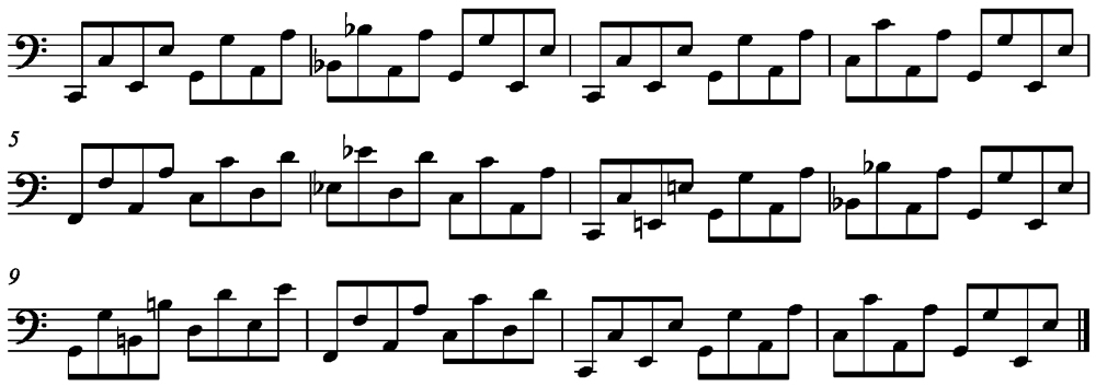
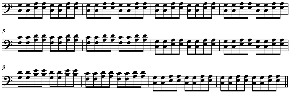
Oral histories indicate that “The Texas and Pacific” bass figure (AKA “the Cows”), the most influential and famous Boogie Woogie bass figure of all time, was developed by piano player(s) who performed at the boarding house used by workers who constructed the Texas & Pacific bridge over the Sulphur River (between Cass and Bowie Counties) in late 1873. The modern-day Railroad bridge that crosses the Sulphur River at this point is hard to get to because it is surrounded by private property. The north shore (Bowie County) of the Sulphur River at this point was known as “Moore’s Landing.” The boarding house where the "Texas and Pacific" bass figure was developed was probably on the Bowie County side of the Sulphur River (See Destination 7).
The "Texas & Pacific" Bass Figure
From the intersection of the railroad tracks and Texas 3129, go westward on 3129 back to Highway 59 and continue northward towards Texarkana to the intersection of Texas 989 (AKA South Kings Highway). Turn right, which will take you southward on South Kings Highway. (Although the track has been taken up, Kings Highway was the original 1873 right-of-way for the Texas and Pacific Railroad when it was first built into Texarkana.) Continue on South Kings Highway until you reach the intersection of South Kings Highway and Cruthers Creek Road.
6. Near the Prior Site of the Buchanan Depot (Bowie County)
The southwest quadrant of this intersection is the approximate location of the prior Texas & Pacific depot of the Buchanan Community. William Smith, engineer for the Texas &Pacific Railroad in the late 1800s, said that the terms “Boogie” and “Boogie Woogie” were being used by African Americans in the 1890s to refer to piano music played by black musicians near the Buchanan Depot in the 1890s.
Go westward on Cruthers Creek Road to Buchanan Road and turn right (southward) on Buchanan Road. Continue southward until Buchanan Road dead ends.
7. Sulphur Community Near Railroad Bridge and Near Prior Site of Moore's Landing (Bowie County)
Your are now at the prior site of the community of Sulphur, which was one stop south of the Buchanan Depot on the T & P Railroad in Bowie County. Moore's Landing was also near here on the north shore of the Sulphur River where the railroad tracks now cross. The southern terminus of Buchanan Road is the closest point on a public road to the most the probable location of the boarding house where the “Texas & Pacific” bass figure was developed. Boarding House Creek is just east of this point, and empties into the Sulphur River.
The community of Sulphur was almost certainly the birthplace of T-Bone Walker's mother Moviela Walker. On page 9 of Stormy Monday (the biography of T-Bone Walker by Helen Oakley Dance), Moviela Walker is quoted as saying:
"Where I was born was called Sulser. It was near Texarkana, I guess. Part was in Arkansas, too, and for a while we lived there as well."
Despite the spelling of "Sulser," it appears that Moviela was referring to the community of Sulphur as the place of her birth. There was no part of Sulphur that was in Arkansas, so it appears that Moviela Walker is saying that she here family also lived in Texarkana (Arkansas and/or Texas) at some point as well.
From here, do a u-turn and drive back to the intersection of Cruthers Creek Road and turn left (westward) on Cruthers Creek Road and drive westward back to South Kings Highway. Turn right on South Kings Highway (AKA Texas 989) and continue northward to the intersection of Will Smith Road (on the West) and Wingwright Blvd (on the east) intersect with South Kings Highway.
8. Near Prior Site of Juke Joint Where Lee Ree Sullivan Learned and Performed Boogie Woogie (Bowie County)
The railroad tracks that cross South Kings Highway just south of this intersection are the Cotton Belt Railroad tracks. Somewhere near this intersection was the juke joint where Lee Ree Sullivan and his mentors performed in the 1950s, at which time the twelve Boogie Woogie bass figures mentioned by Lee Ree Sullivan (in his 1986 interview with John Tennison) were still in use.
Continue northward along South Kings Highway towards (Nash, Texas) to East New Boston Road (US Highway 82).
9. Trans-Continental Junction (Bowie County)
Just south of the intersection of South Kings Highway and East New Boston Road is Cantrell Street (on the east side of South Kings Highway). The portion of South Kings Highway that is south of the intersection at Cantrell Street is part of the original right-of-way of the 1873 Texas & Pacific route into Texarkana. Cantrell Street turns easterly to follow the original Texas & Pacific right-of-way as Cantrell Street comes to run parallel with the modern-day eastward-running railroad tracks. The point where the Texas & Pacific tracks that had run along South Kings Highway met the East/West running tracks that run roughly parallel to New Boston Road was known as “Trans-Continental Junction” because this is the point where the tracks that had been built from the south were to meet the East/West running tracks that were to become a trans-continental railroad line.
Turn right (eastward) on East New Boston Road. Continue eastward and cross under the KCS railroad tracks. Stop at this point.
10. KCS (AKA Texarkana & Northern) Railroad Tracks at New Boston Road (Bowie County)
The railroad tracks that you have just crossed under were originally part of the Texarkana & Northern Railroad, after which a Boogie Woogie bass figure, the "Texarkana & Northern" is said to have been named during the construction of these tracks. Moreover, these tracks were the first tracks constructed in what later became the Kansas City Southern Railroad. The KCS became the most direct route by which itinerant musicians could travel from the Arkalatex to Kansas City, thus spreading musical styles northward. Running north/south in parallel on the east side of the KCS tracks at New Boston Road can be seen Swamp Poodle Creek, for which the Texarkana red light district in downtown Texarkana was also named.
The "Texarkana & Northern" Bass Figure
Continue Eastward until New Boston Road dead ends at Texas Blvd. Turn right (southeasterly) on Texas Blvd. Continue on Texas Blvd. until it dead ends at Front Street in downtown Texarkana.
11. Texarkana (Bowie County, Texas & Miller County, Arkansas)
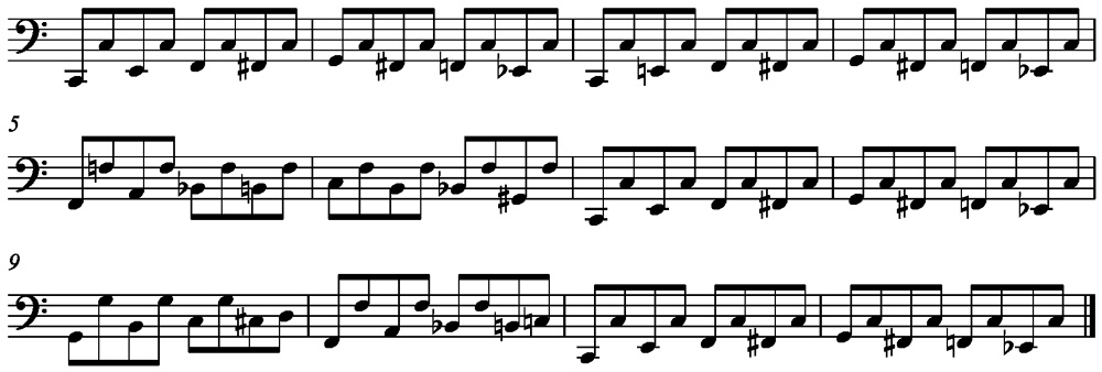
You are now in the approximate geographical center of gravity of “Swamp Poodle,” Texarkana’s former red light district. What is probably the most famous Boogie Woogie bass figures of all time (“Swamp Poodle”) is said to have been developed in Texarkana’s red light district. The Swamp Poodle bass figure is essentially a broken-octave doubling of the Texas & Pacific bass figure, which is said to have been developed at Moore’s Landing.
The "Swamp Poodle" Bass Figure
To the west of the point in downtown Texarkana at Texas Blvd. and Front Street is the portion of Swamp Poodle Creek that was in closer proximity to the red light district than the portion of Swamp Poodle Creek exists where New Boston Road crosses under the KCS railroad tracks.
While in Texarkana, you can visit the Texarkana Historical Museum and see the square piano believed to have been used by Scott Joplin. The museum also has displays about Conlon Nancarrow and Lead Belly. Moreover, you can visit the historical school attended by Scott Joplin on Laurel Street on the Arkansas side of Texarkana. Texarkana, Arkansas is in Miller County, which is the setting for Scott Joplin's Treemonisha opera.
The house where Conlon Nancarrow grew up was on the southeast corner of the intersection of Beech and East 20th Street in Texarkana, Arkansas. There is only a vacant lot there now and some concrete flatwork, as the Nancarrow house burned down.
From Texas and Front Streets, go north one block to Broad Street, turn right (eastward) on Broad Street and continue until you cross under the Arkansas Viaduct, turn left (northward) and loop around to the left until you intersect Hickory Street. Turn left on Hickory Street (which becomes East Street and is also U. S. Highway 71 South). Highway 71 South roughly parallels the Texas & Pacific Track that ran from Texarkana to Shreveport. Continue southward on U.S. Highway 71 until you reach the intersection of County Road 6.
12. Black Diamond Community (Miller County, Arkansas)
The intersection of County Road 6 and U.S. Highway 71 South is at the approximate location of the community of Black Diamond.
The Boogie Woogie bass figure “Black Diamond” is said to have been developed in this community.
The "Black Diamond" Bass Figure
Continue southward along U.S. Highway 71 and you will cross into Louisiana before you reach the community of Ida. Continue southward until you reach the intersection of U. S. Highway 77 and Louisiana 170. Turn left (eastward) on Louisiana 170 towards Gilliam. In Gilliam, turn southward on Louisiana 3049 towards Belcher. Louisiana 3049 is becomes Dixie Shreveport Road. This road will take you parallel to the route of the Texas & Pacific railroad tracks that ran between Texarkana and Shreveport. This road also runs roughly parallel to the Red River to the east. This road will merge with Grimmett Drive. Continue southward on Grimmett Drive. Grimmett Drive will merge with Clyde E. Fant Memorial Parkway, which parallels the Red River. Continue southward on Clyde Fant Parkway until you reach the intersection of Clyde E. Fant Memorial Parkway and Fannin Street.
13. Shreveport, Louisiana (Caddo Parish)
This is the approximate center of gravity of prostitution in Shreveport when Lead Belly was born in 1889. However, the Red Light district that was later officially designated in Shreveport was further down Fannin Street (in a southwesterly direction -- See Destination 14). Lead Belly heard Boogie Woogie bass figures being played on piano on Fannin Street. The Boogie Woogie bass figure known as the “Shreveport” bass figure is said to have been developed in Shreveport.
The "Shreveport" Bass Figure
While in Shreveport, visit the Lead Belly statue at Texas and Marshall Streets.
From Fannin Street at Clyde Fant Memorial Parkway, travel on Fannin Street until you reach Baker Street. Turn right on Baker Street and continue on Baker Street until it dead ends just past View Street.
14. The Texas & Pacific Railroad Boundary of Shreveport’s Red Light District
If you could have continued on Baker Street you would have crossed directly over the where the Texas & Pacific tracks used to exist. The old rail bed can still be seen, especially from aerial satellite photos. Before these tracks were taken up, they formed the northwestern boundary of the area that the city of Shreveport officially recognized as its Red Light District in late 1902. There were various small houses on what was this side of the track where prostitution occurred. There were also some larger brothels nearby where piano players performed. It is possible that the piano players first heard by Lead Belly were not within the Red-Light Boundaries recognized in late 1902 by the city of Shreveport, but rather, might have been on the portion of Fannin Street on the other side of Common Street (towards the Red River).
From here, take View Street until it wraps around and meets up with Louisiana 173. Turn right on Louisiana 173 (which becomes Ford Street). This street then becomes Shreveport-Blanchard Highway. Continue on Shreveport-Blanchard Highway to Blanchard and turn left (westward) on Blanchard-Latex Road. Travel for about 2.2 miles until you reach the Shiloh Baptist Church on the South side of Blanchard-Latex Road.
15. Lead Belly’s Gravesite at Shiloh Baptist Church
Behind Shiloh Baptist Church is the cemetery where Lead Belly’s gravestone is located.
From Shiloh Baptist Church, continue traveling westward (towards the Texas Border). Immediately before you reach the Texas border, you will reach the intersection of Blanchard-Latex Road with State Line Road. Turn right (northward) on State Line Road. Continue northward on State Line Road. Just south of Caddo Lake, State Line Road will move over the state line into Texas in a northeasterly direction, where it becomes known as North State Line Road. Continue on North State Line Road until it dead ends on the southern shore of Caddo Lake (near Swanson’s Landing).
16. Swanson’s Landing on Caddo Lake (Harrison County, Texas)
Swanson’s Landing is extremely important in that it was the location in the late 1850s from which the Railroad track was first built and from which the first locomotives in Harrison County ran. These earliest locomotives had been transported by steam boat up the Red River and then to Swanson’s Landing on Caddo Lake. The beginning of the operation of locomotives at Swanson’s Landing in Harrison County made it possible for Marshall, TX to become the Birthplace of Boogie Woogie.
Do a U-turn on North State Line Road and go southward until you reach the intersection of North State Line Road with Swanson’s Landing Road. Turn right (westward) on Swanson’s Landing Road. Continue on Swanson’s Landing Road until you reach its intersection with FM-1999. Turn left (southward) on FM-1999. Continue southward until you reach the intersection of FM-1999 with Texas 1999 and Texas 9. Turn left (westward) on Texas 1999. Continue westward until you reach the intersection of Texas 1999 with Texas 134.
17. Leigh, Texas (Harrison, County)
Leigh, Texas, is the community where Lead Belly grew up. His first memories of hearing music almost certainly occurred in the area of the Leigh community in Harrison County, Texas.
Despite claims by some that Lead Belly was born in Louisiana, Lead Belly himself said he was born on his father's farm near Leigh. Specifically, historian and journalist Frank Tolbert, in the 1983 book, "Tolbert's Texas," writes the following about Lead Belly on page 11:
"He told me he was born on his father's farm near the village of Leigh, Texas, in Harrison County and only a mile or so from the Louisiana state line."
Continue westward on Texas 134, where it will very quickly turn left (southward). Continue southward on Texas 134 to the intersection of Texas 134 with Bellview Road.18. Jonesville, Texas (Harrison County)
You are now in the Jonesville community. During the Civil War the railroad tracks between Swanson’s Landing and Mile Marker 14 (slightly southwest of the original location of Jonesville, TX piror to 1863) were taken up and re-laid towards Louisiana with the intention of connecting with Shreveport. At the time the tracks were re-laid, the community of Jonesville was moved about 1 mile southeast of its original location. Thus, the Jonesville in which you are now located is not at the same location as the Jonesville which had a rail connection to Swanson's Landing. That is, the modern-day location of Jonesville never had a rail connection to Swanson's Landing.
By July 29, 1866, the line through the current-day location of Jonesville (between Marshall and Shreveport) was open for public traffic. Running parallel with Bellview Road on the south side of Bellview Road are these tracks.
While in Jonesville, visit the T. C. Lindsey & Company General Store. The store is at the intersection of Texas 134 and Bellview Road.
From Jonesville, go westward on Bellview Road. Follow Bellview Road on what is almost a sharp left turn over the Texas & Pacific railroad tracks. This point where Bellview Road crosses the Texas & Pacific tracks is Mile Marker 14.
The 12 miles of railroad track from Mile Marker 14 westward into Marshall utilize the original right-of-way put into operation possibly as early as late 1858, but no later than 1859. These 12 miles of right-of-way have been in continuous operation ever since the track on this 12 miles of right-of-way was completed from the track that had been built from Swanson's Landing. I call these 12 miles "Birthplace Way" (which is short for "Birthplace of Boogie Woogie Right of Way"). (Technically, Birthplace Way is slightly under 12 miles with the last western-most "mile" being slightly under 1 mile.)
The 12 Miles of Birthplace Way
After having crossed over the tracks at the eastern end of Birthplace Way (mile marker 14), continue on Bellview Road where it will now briefly parallel the south side of Birthplace Way, then Bellview Road will turn (left) due south to reach the intersection of Bellview Road with the Frontage Road for Interstate 20. Turn right (westward) on this Frontage Road and stay on the Frontage Road. It will become U. S. Highway 80. Continue westward on U. S. Highway 80 until you reach the point where it intersects FM-2199. Turn right (northward) on FM-2199. Continue northward on FM-2199 until you reach the intersection of FM-2199 with Texas 1998.
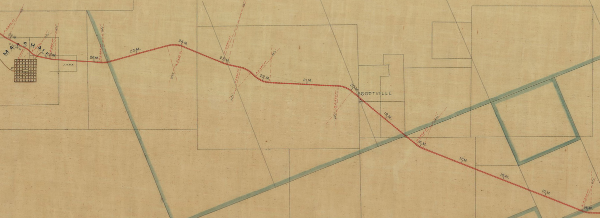
19. Scottsville, Texas (Harrison County)
You are now in the Scottsville community. Scottsville is on Birthplace Way, and is one of the earliest and most important depots on the railroad track that had been built from Swanson’s Landing in the late 1850s.
From Scottsville, continue westward on Texas 1998 (AKA Scottsville Road) until you reach the intersection of Scottsville Road with Victory Drive (U. S. Highway 80). Turn right (westward) on Victory Drive. Continue westward on Victory Drive until you reach the Algoma Cemetery, which straddles both the north and south sides of Victory Drive. Turn into the north side of the cemetery.
20. Marshal, Texas – Gravesite of Omar Sharriff (Harrison County)
Omar Sharriff, who grew up in Marshall, was buried in the part of Algoma Cemetery that is north of Victory Drive on January 14, 2012.
The northern part of Algoma Cemetery is extremely close to the point on the railroad tracks that was the western terminus of Birthplace Way. Although this point is within the Marshall city limits at this time, Texas Railroad Commission records indicate that, when first constructed, the track was constructed to a point "1 Mile east of Marshall." Thus, when steam locomotives first made what was described as their first trip "to Marshall," the locomotives actually stopped at a point that was 1 mile east of the Marshall city limits (as pictured in the 1860 map above).
From the Algoma Cemetery, get back on Victory Drive (U.S. Highway 80) and continue westward over Highway 59 and through Marshall (where Highway 80 will become Grand Avenue. Continue westward on Grand Avenue (U. S. Highway 80) until you reach the intersection of U. S. Highway 80 with Texas 450. Before arriving at this intersection, you will notice that you have come to run parallel with the Texas & Pacific Railroad tracks on the south side of U. S. Highway 80.
21. Hallsville, Texas (Harrison County)
You are now in Hallsville. This site is the prior location of the locomotive shops of the Southern Pacific Railroad of Texas, a precursor railroad to the Texas and Pacific. The first locomotives of the Texas & Pacific were those for which the T&P came into possession when the Texas & Pacific absorbed the Southern Pacific (of Texas) in 1872.
Continue westward (towards Longview) on U. S. Highway 80, which will continue to run parallel with the Texas & Pacific railroad tracks. As it enters Longview, U. S. Highway becomes Marshall Avenue. Continue westward until you reach the intersection of Marshall Avenue with North 6th Street. Turn left (southward) on North 6th Street. Continue southward until you reach the intersection of North 6th Street and East Methvin Street. Turn right (westward) on East Methvin Street. Travel only for 1 block and then turn left (southward) on North Mobberly Avenue. Continue southward under the Texas & Pacific railroad tracks and turn left (eastward) onto East Pacific Avenue, which is the very first intersection after crossing under the tracks. Continue eastward to the end of East Pacific Avenue.
22. Longview, Texas (Harrison and Gregg County)
You are at the site of the Texas & Pacific Depot in Longview.
Longview is important because it was the town from which the southward-bound railroad tracks were built from the pre-existing Texas & Pacific tracks that had been built westward from Marshall. In 1873, the southward-bound tracks were connected to the tracks that had been built northward from Houston to Palestine, thus establishing the first north-south railroad corridor through the Piney Woods of East Texas. From north to south, some towns along the route of this north-south corridor are Texarkana, Atlanta, Jefferson, Marshall, Hallsville, Longview, Kilgore, Troup, Jacksonville, Palestine, Crockett, Trinity, Conroe, and Houston.
From the Texas & Pacific Depot in Longview, drive westward on East Pacific Avenue back to North Mobberly Avenue and turn left (southward). Drive to the next intersection and turn right (westward) on East Cotton Street. Drive westward on Cotton Street until you reach the intersection of West Cotton Street and Texas 31. Turn left (southward) on Texas 31. When you reach Interstate 20, continue under Interstate 20, at which point Texas 31 will become U. S. Highway 259. After you reach Kilgore, turn right on North Kilgore Street and then right on West Lantrip Street. Go one block on West Lantrip Street and turn left on North Commerce Street. Continue 4 blocks and stop at the intersection of North Commerce Street and East Main Street.
23. Kilgore
Kilgore was one of the towns on the north-south railroad corridor that was completed in 1873 between Longview and Houston.
Continue along Commerce Street several blocks until it intersections with Texas 135. Follow Texas 135 through Overton to Texas 64, just northeast of Arp, Texas. Turn right on Texas 64 and follow Texas 64 to until it becomes East 5th Street in Tyler. Continue westward until you reach Texas 155. Turn right (northward) on Texas 155 and continue until you reach the intersection of Texas 155 and Front Street.
24. Tyler, Texas (Smith County)
The “Tyler Tap” Boogie Woogie bass figure is said to have been developed at the site(s) of construction of the Tyler Tap Railroad, a tap line that was built between Big Sandy and Tyler.
The "Tyler Tap" Bass Figure
Continue northward on Texas 155 as it crosses under Interstate 20 and parallels the Cotton Belt Railroad tracks headed for Big Sandy. When you reach the intersection of West Cotton Street in Big Sandy, turn right and follow West Cotton Street to South Tyler Street. Turn left (northward) on South Tyler Street and cross over the Texas & Pacific railroad tracks. Stop at the very next intersection at West T & P Avenue.
25. Big Sandy (Upshur County, Texas)
Big Sandy is an important town in the history of Boogie Woogie. The “Big Sandy” Boogie Woogie bass figure is said to have been developed here. Also, Henry “Ragtime” Thomas (whose life was researched and elucidated by historian Mack McCormick) was born in Big Sandy. Henry Thomas’s famous piece, “Railroadin’ Some” mentions various Texas & Pacific Railroad stops between Fort Worth and Texarkana, one of them being Big Sandy.
The "Big Sandy" Bass Figure
T and P Avenue is, of course, named after the Texas & Pacific Railroad. In many other instances there is an occurrence of a “Pacific Avenue” in proximity to what had originally been Texas & Pacific railroad tracks.
Continue 2 more blocks northward on South Tyler Street until you reach Broadway Street (AKA U. S. Highway 80). Turn right (eastward) and continue towards Gladwater. In Gladewater, turn right on West Pacific Avenue and parallel the Texas & Pacific tracks for several blocks before Pacific Avenue dead ends at Money Street. Turn left (northward) on Money Street and then right (eastward) on Broadway (U. S. Highway 80) towards Longview. Continue back into Longview, where U. S. Highway 80 will become West Marshall Avenue. Turn right (Southward) on High Street (AKA Texas 322). Continue southward on High Street (AKA Texas 322) until it crosses under Interstate 20 and merges with Texas 149 (AKA Estes Parkway). Continue on Estes Parkway and turn left on Kennedy Avenue. Continue on Kennedy Avenue to the intersection of Kennedy Avenue and Main Street in Easton.
26. Easton (Gregg and Rusk Counties)
Easton is a town with a predominantly African American population. In contrast to other East Texas towns which have substantially grown in population and multi-story buildings, Easton has maintained a rural look and feel that is closer to a 19th-Century railroad town in East Texas.
Drive southward on Main Street, which becomes Easton Road. Continue on Easton Road back to Texas 149 and turn left. Continue on Texas 149 towards Tatum, TX. Texas 149 will become North Hill Street in Tatum. When you reach Johnson Street in Tatum, turn left (eastward) and travel until you reach South Jefferson Street (just before the Railroad Tracks).
27. Tatum (Panola and Rusk Counties)
Tatum is the probable birthplace of Tom Elam, father of Omar Sharriff. Tom Elam was born in 1893. He was the first person that Omar Sharriff ever heard play Boogie Woogie. Tom Elam was a mule skinner who worked in the logging industry on the Sabine River. The Elam family lived on the other side (east side) of the tracks that are now in front of you.
Do a U-turn on Johnson Street (AKA Texas 43) and follow Texas 43 in a southwestern diretion towards Henderson, Texas. When you reach the intersection of Texas 64 in Henderson, turn right (westward) on Texas 64. Continue on Texas 64 until you reach North Mill Street. Turn left (southward) on North Mill Street. Stop at the intersection of North Mill Street and Waskom Street.
28. Henderson (Rusk County)
While in Henderson, visit the Depot Museum.
Do a U-turn and take North Mill Street northward back to Texas 64. Turn left (westward) on Texas 64 and follow Texas 64 until you reach the intersection of Texas 64 and Texas 135 (just northeast of Arp, Texas). Turn left on Texas 135. Follow Texas 135 through Arp to Troup, Texas. In Troup, Texas 135 will also be known as South Railroad Street. Continue southward until you reach the intersection of Texas 135 with FM-2064. Turn left on FM-2064, which will take you in a southerly direction towards Jacksonville. FM-2064 will come to closely parallel the railroad tracks that lead towards Jacksonville. Before entering Jacksonville, FM-2064 will merge back into Texas 135. Continue on Texas 135 in southwestern direction towards Jacksonville. After entering Jacksonville, turn left (southward) on U. S. Highway 69 (Jackson Street). Go over the railroad tracks until you reach Rusk Street (AKA U. S. Highway 79).
29. Jacksonville, Texas (Cherokee County)
Jacksonville is one of the towns that is served by the north-south railroad corridor through the Piney Woods that was completed in 1873 between Longview and Houston.
At the intersection of U. S. Highway 69 (Jackson Street) and Rusk Street (U. S. Highway 79), turn right (westward) and continue towards Palestine. U. S. Highway 79 will roughly parallel the railroad tracks as you travel southwesterly towards Palestine. As you approach Palestine, U. S. Highway 79 will become East Palestine Avenue. Continue westward until you reach the intersection of East Palestine Avenue with N. Mallard Street (AKA Texas 19). Turn left (southward) on North Mallard Street. North Mallard Street will become Crockett Road. You will cross over railroad tracks. Continue southward until you reach the intersection of Crockett Road and East Park Avenue (AKA U. S. Highway 84).
30. Palestine, Texas (Anderson County)
Palestine is an important town in the history of the spread of Boogie Woogie music and quite possibly of popular forms of American dancing, including, but not limited to what is called Boogie Woogie dancing.
In 1873, Palestine is the town where the northwardly-constructed railroad tracks from Houston met up with the southwardly-constructed tracks from Longview. Thus, Palestine became the municipal connecting link in the first north-south rail corridor through the Piney Woods of East Texas. Modern Palestine is important because it is home to one of the two main depots of the Texas Railroad, which runs on the only operative Texas & Pacific steam locomotive at this time (See Destination #31).
A famous dancing slave, “Tom from Palestine” was so named because he was said to be from the Palestine, Texas area. In the 2009 book, “Ballroom, Boogie, Shimmy Sham, Shake: A Social and Popular Dance Reader,”(editor Julie Malnig), the following is stated with regard to the famous dance known as the “Texas Tommy”:
“The Texas Tommy bridged ragtime dancing and swing dancing. Many consider it to be the first swing dance because it was the first to include a breakaway from a closed partnering position to an open position that allowed for acrobatics, antics, improvisations, and showing off. After the couple did the basic step of a kick and three hops on each foot, they would break away and improvise in keeping with the timing in order to come back together for the basic step again.”
and
“A ‘Texas Tommy’ was a female prostitute who worked in the ‘trenches’ in the early 1900s. There are also rumors of the dance going back the Civil War, in which a famous black dancer named ‘Tom from Palestine’ (Texas) put a glass of water on his head and frenetically moved his lower half without spilling the water. Another rumor has the dance originating in eastern Texas by a blues singer, ‘Ragtime Texas Henry’ Thomas, who played jook joints in the late 1800s.”
Recall that Henry “Ragtime Texas” Thomas had been born in Big Sandy, which was a town on the Texas & Pacific railroad and after a which the “Big Sandy” Boogie Woogie bass figure had been named.
Turn right (eastward) on East Park Avenue (U. S. Highway 84) and continue eastward past Loop 256 until you reach the entrance to the Texas State Railroad on the south side of U. S. Highway 84.
31. Texas State Railroad (Anderson & Cherokee Counties)
The Texas State Railroad owns and operates Texas & Pacific steam locomotive 316. T &P 316 is the only Texas & Pacific steam locomotive that is still operational. Riding the T & P 316 is a thrilling experience and is a must for anyone who wants to come as close as possible to experiencing how the sounds of steam locomotives in the Piney Woods of East Texas were inspirational to the creators of Boogie Woogie. For more information on the T & P 316, see my article, “The Texas & Pacific Locomotive 316 Sounds Like Boogie Woogie.”
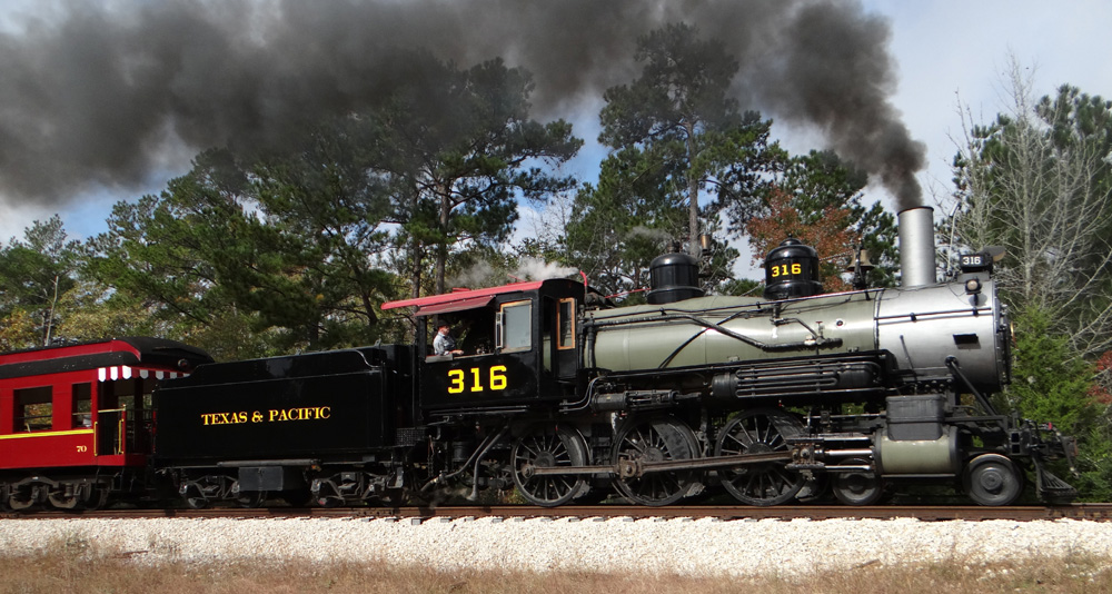
Spend a day at the Texas State Railroad to make a round-trip excursion between Palestine and Rusk on the Texas & Pacific 316.
After returning to the Texas State Railroad Depot in Palestine, get back on U. S. Highway 84 and go westward back into Palestine until you reach the Crockett Road intersection. Turn left (southward) on Crockett Road (AKA Texas 19 and U. S. 287). Continue southward through Elkhart and Grapeland to Crockett. This route roughly parallels the railroad track southward to Houston. After entering Crockett, turn right (westward) on East Goliad Street (AKA Texas 21). Go westward only 1 block, turn left (southward) on Camp Street (AKA 3rd Street), and stop after traveling half a block.
32. Crockett, Texas (Houston County)
Visit the statue of Sam Lightnin’ Hopkins on the west side of Camp Street. Sam Lightnin’ Hopkins was one of the most important Texas bluesmen of the 20th Century. Although he was not born in Crockett, he spent a significant amount of time performing in Crockett while growing up. (Sam Lightnin’ Hopkins was born to the west, in Centerville, Texas.)
From Crockett Texas, get back on Texas 19 (South 4th Street) and continue southward through Lovelady, Texas to Trinity Texas. This route will continue to keep you roughly parallel with the railroad tracks southward towards Houston. After arriving in Trinity, turn left (eastward) at the intersection of Texas 19 (AKA South Robb Street) and Railroad Street. Railroad Street will turn southward. Follow Railroad Street 2 blocks to the intersection of Railroad Street and Main Street and stop.
33. Trinity, Texas (Trinity County)
Although I consider it unlikely that Boogie Woogie was first played in turpentine camps, such camps have nonetheless been mentioned in oral histories as locations where early Boogie Woogie was played. Trinity, Texas is significant in that, when the northwardly-constructed tracks from Houston met the southerly-constructed tracks from Longview in 1873, Trinity was the municipality along this north-south corridor that was closest to the longleaf pine forests of Texas (in eastern Trinity County), from which turpentine production occurred. Nonetheless, by 1873 standards, Trinity, Texas (in the western extreme of Trinity County) was still a good distance away from the longleaf pine areas in Trinity County, which were predominantly in the eastern part of Trinity County. Still, on the railroad corridor established between Longview and Houston in 1873, Trinity would have seemingly been the most likely municipality that could have had connections to turpentine production, even if not by rail at first. For further information, see my article: “Why Boogie Woogie is Unlikely to Have Originated in Turpentine Camps.”
Go southward on Railroad Street to Alamo Street and turn right (westward). Go one block and turn left (southward) back onto South Robb Street (AKA Texas 19). Continue on Texas 19 until you reach the intersection of Texas 405, at which point turn left onto Texas 405, which will continue to take you southward while very closely paralleling the railroad tracks towards Conroe. While on Texas 405, you will enter the Sam Houston National Forest. Texas 405 will dead end at U. S. Highway 190 in the Sam Houston National Forest. Turn right on U. S. Highway 190, which will continue southwardly, which will continue to parallel the railroad tracks. When you reach the intersection of U. S. Highway 190 with Texas 2296, turn left (southward) onto Texas 2296. Texas 2296 will dead end at Texas 75. Turn left (southward) onto Texas 75. Continue southward on Texas 75. You will exit the Sam Houston National Forest before reaching New Waverly. Continue southward from New Waverly on Texas 75 to Willis. From Willis, continue southward on Texas 75 to Conroe. Texas 75 will merger with South Frazier Street in Conroe. Continue southward on South Frazier Street until you reach South Loop 336. Turn right (westward) on South Loop 336 and go under Interstate 45. Turn left (southward) on the access road and get Interstate 45 towards Houston. After arriving in Houston, take Interstate 10 east from Interstate 45. When Interstate 10 East reaches Highway 59 North (“The Boogie Woogie Highway”), you will be in proximity to Houston’s 5th Ward.
34. Houston, Texas (Harris County)
There are opportunities to see a multitude of historically important areas while in this general vicinity of Houston. In future updates to this article, I will describe significant destinations. For now, keep in mind that the George W. Thomas family (AKA “The First Family of Boogie Woogie”) was based in the 5th Ward of Houston.
From the intersection of Interstate 10 and Highway 59, continue northward on Highway 59 (AKA “The Boogie Woogie Highway”). Highway 59 roughly parallels the railroad tracks that were originally the HEWT line (Houston East and West Texas) to Shreveport. Continue northward on Highway 59 through Cleveland, Goodrich, Livingston, Moscow, Corrigan, and then stop in Diboll at the History Center (on the east side of Highway 59 just past the intersection of Thompson and Dennis Streets with Highway 59).
35. Diboll, Texas (Angelina County)
Visit the History Center in Diboll. The History Center contains an excellent archive of old photographs pertaining to the lumber industry and logging camps. While at the History Center, be sure to see Steam Locomotive 13 and blow its live whistle (which runs on compressed air). It sounds GREAT!
From the History Center, get back on Highway 59 and continue northward to Lufkin, Texas.
36. Lufkin, Texas (Angelina County)
While in Lufkin, be sure and visit the Texas Forestry Museum, 1905 Atkinson Drive, Lufkin, TX 75901, phone (936) 632-9535. Like the History Center in Diboll, the Texas Forestry Museum also has a great collection of historic photographs pertaining to the Texas lumber industry.
From Lufkin, continue northward on Highway 59 to Nacogdoches, Texas.
37. Nacogdoches, Texas (Nacogdoches County)
While in Nacogdoches, be sure and visit the beautiful piney-wooded campus of Stephen F. Austin State University. See the Shay steam locomotive on display at the Stephen F. Austin State University campus. Like the History Center in Diboll and the Texas Forestry Museum, the library of the Stephen F. Austin University also has a fine collection of historic photographs pertaining to the logging industry of East Texas.
From Nacogdoches, continue northward along the Boogie Woogie Highway (Highway 59) through Garrison, Timpson, and then to Tenaha. At Tenaha, do NOT take the U. S. Highway 59 north, but rather, continue eastward on U. S. Highway 84 to Logansport, Louisiana, which is just over the Sabine River.
38. Logansport, Louisiana (DeSoto Parish)
Logansport is an important logging town and was a popular destination of itinerant Boogie Woogie piano players and other musicians. In a 1972 interview, musician Jesse Thomas stated the following about Boogie Woogie pianist Will Ezell:
"He played around Loganport at this big mill there at Hasland [sic] Texas, just across the water, about a mile from Logantport. I think he drifted in there playin'. In those days there weren't no jukeboxes or many bands. He was the piano player there in the big dance hall at the mill."
From Logansport, take Louisiana 5 northward towards Shreveport. At Keachi, Louisiana 5 will turn eastward. At this point, transition onto Louisiana 789 (going northward). Continue northward on Louisiana 789 until you reach the intersection of Louisiana 789 with Keithville Keatchie Road. Turn right (eastward) on Keithville Keatchie Road. This road will roughly parallel the railroad tracks as they enter Shreveport. Follow Keithville Keatchie Road until it dead ends at Old Mansfield Road. Turn left (northward) on Old Mansfield Road. At the intersection of Old Mansfield Road with Mansfield Road (U. S. Highway 171) turn left (northward) onto Mansfield Road. Continue northward into Shreveport on U. S. Highway 171. Be sure to split off onto Hearne Avenue in order to stay on what is also U. S. Highway 171. Continue northward on Hearne Avenue until it intersects with Greenwood Road (AKA U. S. Highway 79). Turn left (westward) on Greenwood Road. Follow Greenwood Road over the Texas and Pacific Railroad tracks and then under the Interstate 20 to arrive at the community of Greenwood at the intersection of Greenwood Road and Louisiana 169.
39. Greenwood, Louisiana (Caddo Parish)
The “Greenwood” Boogie Woogie bass figure is said to have developed in the community of Greenwood, Louisiana.
The "Greenwood" Bass Figure
From Greenwood, continue westward on Greenwood Road, which will become U. S. Highway 80. Before entering Texas, U. S. Highway 80 will cross back under Interstate 20, where it will begin roughly paralleling the Texas & Pacific tracks. Cross over the state line into Texas and then into Waskom. Branch off to the right onto Waskom Avenue and continue to the intersection of Waskom Avenue and North Lake Street.
40. Waskom, Texas (Harrison County)
The “Waskom” Boogie Woogie bass figure is said to have developed in the Waskom, Texas area.
The "Waskom" Bass Figure
Continue westward on Waskom Avenue until it dead ends at Texas 134. Turn right (northward) on Texas 134. Continue on Texas 134 until you reach Jonesville. Go southward on Jonesville Cutoff Road until you reach the Frontage road for Interstate 20 West. Follow the Frontage Road westward until it becomes U. S. Highway 80. Continue westward on U. S. Highway 80 into Marshall to the Intersection of U. S. Highway 80 and Highway 59 (The Boogie Woogie Highway).
41. Marshall, Texas (Harrison County)
You have now completed the Boogie Woogie Heritage Tour!
You are in the Birthplace of Boogie Woogie on the Boogie Woogie Highway. Where you go from here is up to you.
In future updates to this article I will add more details, maps, and images of sites to see at each of the destinations. If anyone has any suggestions for improvements corrections to this article, please contact me at nonjohn@yahoo.com.
Keep on Boogie-ing,
John Tennison, MD